General surveying and comprehensive legal property services
At Geo Company Sp. z o.o., general surveying is more than just a measurement. It is the process of providing documents that define the legal status of your property and serve as the foundation for designers and contractors. With 9 branches in Poland, we perfectly understand the specifics of local surveying documentation centers, allowing us to process your cases efficiently.
Legal documentation, subdivisions, and boundaries
Our licensed surveyors specialize in regulating the legal status of real estate. We provide full support for complex procedures, taking care of every detail of the documentation. Our scope of legal work includes:
-
Property subdivisions: Preparation of documentation necessary for creating new plots.
-
Boundary delimitation and recovery: Resolving boundary disputes and precise restoration of boundary points on the ground.
-
Legal documentation: Preparing land change registers and synchronizing data with land and mortgage registers.
Topographic maps for design and survey control networks
Every construction project begins with a map. We deliver precise topographic maps for design purposes in digital and analog forms, which are the foundation for architects’ work. We also provide:
-
Design and installation of control networks: Building stable measurement bases for large construction sites.
-
Site and elevation surveys: Detailed reflection of terrain features and underground utilities.
-
Digital Terrain Model (DTM): Digital mapping of terrain relief, essential for advanced engineering calculations.
As-built surveys and building inventory
The completion of construction requires formal confirmation of compliance with the design. We perform reliable as-built surveys, which are a necessary condition for obtaining an occupancy permit. We inventory buildings, connections, and utility networks, recording them on base maps.
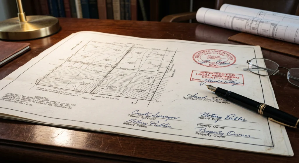
Map for legal purposes – when is it necessary?
In many administrative and judicial processes, a map for legal purposes constitutes key evidence and a mandatory attachment. It is essential primarily in cases regarding adverse possession of property, establishing transmission easements, or during property division processes. Every such map must be prepared by a licensed surveyor and submitted to the state surveying and mapping resource.
It is important to remember that a map for legal purposes contains specific information regarding ownership boundaries and property encumbrances that cannot be found on standard base maps. Our developments are characterized by the highest clarity and precision, which is extremely important for judges, notaries, and administrative bodies. We provide reliable support in preparing this document, ensuring compliance with the current legal status.
Surveying documentation for a building permit step by step
The process of obtaining building permits requires the submission of a series of documents, among which surveying documentation for a building permit holds a central position. We begin by updating the base map and creating a topographic map for design purposes, which becomes the foundation for the architect. Next, we assist in developing designs for utility connections and networks, which is a prerequisite for receiving a positive administrative decision.
Comprehensive surveying documentation for a building permit also includes opinions and design coordination (utility coordination). Our office ensures that all applications are completed correctly and delivered on time to the appropriate surveying departments. As a result, the investor can focus on planning the construction, having the certainty that the formal side is in the hands of specialists.
Plot subdivision by a surveyor – formalities and the process
A correctly performed plot subdivision allows for the optimal use of land potential or its preparation for sale. This process begins with a preliminary subdivision design, which must comply with the Local Spatial Development Plan (MPZP) or the decision on land development conditions (zoning). The surveyor marks new boundaries in the field and, after obtaining the appropriate decisions, prepares documentation to update the changes in the land and mortgage registers.
We support our clients at every stage of this complex process, explaining the intricacies of the procedures and ensuring a fast pace of work. Plot subdivision requires not only measurements but also extensive knowledge in the field of real estate management. Our experience allows for the efficient resolution of problems related to unclear boundaries or a lack of archival documentation.
Surveying development of a construction project – technical requirements
Precise surveying development of a construction project is essential for the architect’s vision to be safely transferred to the ground. We analyze the technical requirements contained in the project and prepare data for the setting out of objects and networks. Our technical reports form the foundation for the site manager, allowing for the accurate placement of structures in accordance with elevation levels.
We ensure that every surveying development of a construction project meets rigorous accuracy standards. We use modern CAD software, which enables the seamless exchange of data with design offices. Thanks to this, we eliminate the risk of interpretative errors that could affect the stability of the structure or compliance with the building conditions.